Buy the Book
Published By Lankelma
Lankelma is the foremost contractor for onshore in-situ soil testing in the UK. An acknowledged
specialist in CPT, Lankelma also offers a worldwide consultancy and training service.
A.P. van den Berg develops, designs and manufactures geotechnical and environmental soil
investigation equipment for onshore and offshore applications. Specialists in CPT systems and equipment.
Gardline
Gardline Geosciences offers worldwide marine geotechnics, in-house consutancy and services with marine
investigations ranging from nearshore to full ocean depth (down to 3000m).
About the Author
Hans Brouwer studied civil engineering at Delft University in The Netherlands. He has
worked as a part-time lecturer at Amsterdam Polytechnic and was senior partner in a structural
engineering consultancy. He has written a standard textbook in Dutch about the design of
building foundations. He now lives in England where he writes technical textbooks in
English, hopefully to reach a bigger readership.
Quick Links:
Chapter 10
Offshore testing
Seabed resistivity systems
SEABED RESISTIVITY SYSTEMS 10.4 |
| |
Method
An electrical current is injected into the sub-surface by means of two
electrodes. Based on the measured values of current and voltage, the
average resistivity of the sub-surface is calculated for a sub-surface
volume down to a certain penetration depth. The penetration depth
depends on the distance between the electrodes. Larger electrode
distances are associated with increasing penetration depth.
If the measurements are repeated with increasing electrode distances,
information is obtained from progressively deeper geological
structures. As such, a field curve is obtained showing the resistivity as a
function of the (horizontal) distance between the electrodes. After
computer modelling this field curve is transformed into a real
geophysical subsurface section showing the resistivity as a function of
depth (Figure 105).
|
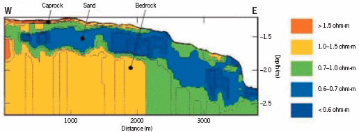 Figure 105 Profile of seabed sub-surface (Source: Demco NV)
| |
The resistivity of a geological structure depends on its porosity, water
saturation and the pore water resistivity. Gravel usually has a lower
porosity than sand and its resistivity thus is higher. Clay with generally
very high porosities shows very low resistivities. Solid rock, on the
other hand, has a low porosity and shows very high resistivities. Each
geological structure tends to have its own specific resistivity.
Fluvial and marine operations
For water based operations the electrodes are placed on a multichannel
cable trailing behind the survey vessel (Figure 106). According
to the circumstances the cable may be floating or towed on the
seafloor. A floating cable may be more efficient in shallow water or if
obstacles on the seafloor hamper the use of a bottom towed cable. The
electrode geometry is chosen in such a way that good quality data may
be obtained even for shallower targets.
|
| | 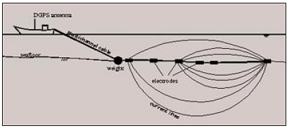
Figure 106 Marine resistivity array (Source: Demco NV) |
| |
While the survey vessel is sailing, measurements are carried out and
stored automatically without any intervention from the operator.
Consequently an entire electrical sounding may be obtained every 3 or
4 seconds; and at a speed of 1 m/sec this corresponds to a horizontal
resolution of one sounding every 3–4 m. In applications concerning the
exploration of alluvial diamonds this resolution is needed to detect even
the smaller diamond-bearing potholes and buried channels.
During the field survey, qualitative results are already shown on the
computer screen. The quality of the field data is monitored online so
that the operator can intervene at any moment to adjust and optimise
the survey parameters.
The final result of the survey gives a continuous profile of the subsurface
of the seabed, as shown in Figure 105.
Applications
Typical applications are:
- dredging reconnaissance
- sand search
- port development
- sand and gravel exploration
- cable and pipe route surveys
- diamond and gold exploration.
|
<< Previous Page